SANTORINI
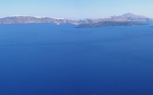
Santorini, along with Nisyros, is one of the two youngest and most active volcanoes in the Aegean region. It began to form approximately 700,000 years ago. Over the last 360,000 years, large shield volcanoes made of basalt and the complexes of domes and thick lava flows of rhyodacite, created by the continuous mild volcanic activity, have been destroyed every approximately 30,000 years by a massive volcanic eruption. Twelve such eruptions have been recorded on Santorini. The eruption of the Late Bronze Age gave the island complex its present form (Thira, Thirasia, Aspronisi), creating a majestic caldera, which was largely submerged by the sea, forming a landscape of unique beauty and geological significance.
The most recent and best-known eruption occurred in 1614 BC, during the Late Bronze Age, a time when Santorini was flourishing with a brilliant civilization similar to that of Minoan Crete. For this reason, as well as because this eruption was mistakenly associated with the downfall of the Minoan civilization in Crete, it is also referred to as the "Minoan" eruption. It is likely the largest volcanic eruption experienced by humans in the last 10,000 years. Archaeological excavations over the last 40 years have uncovered wonderful finds and accumulated valuable information about the life and activities of the inhabitants of Santorini at the time, buried under the volcanic ash of the eruption.(image The city of the Late Bronze Age, at Akrotiri)
Another widely discussed topic involving the "Minoan" eruption of Santorini is the case of Atlantis. Scholars of the distant past, philosophers, and social psychologists have thoroughly documented that major natural disasters are recorded in prehistoric times as myths, to which religious and ideological elements are added. For instance, the major climatic changes and the rapid rise in sea level, from 135 meters below the present level 19,000 years ago to 1 meter below the present level 3,000 years ago, have been recorded in the "collective memory" of humanity as the "deluge." It is described in corresponding myths of numerous cultures across the globe, such as Deucalion and Pyrrha of the Greeks, Noah of the Hebrews, etc.
It is thus surprising that Greek mythology does not have any direct references to the great eruption and destruction of Santorini. There are certainly many elements inspired by volcanic activity, but no direct reference like those for Nisyros and Polybotes or Etna and Typhon. The closest indirect reference in mythology concerns the giant Talos, who protects Crete by repelling the fiery projectiles launched against it.
Based on the above, a number of scientists consider that Plato's Atlantis may have been inspired by the collective memory of the destruction of Santorini and its civilization by the "Minoan" eruption. The seismologist Angelos Galanopoulos, with a famous article in 1960, presented a series of strong arguments for identifying Atlantis with Santorini. Since then, this hypothesis has become one of the strongest. To this day, Santorini and the broader region of the South Aegean are considered by those who approach the Atlantis hypothesis as scientifically plausible, one of the most likely sites for its existence.
Beyond this crucial contribution to humanity through the preservation of the Late Bronze Age settlement at Akrotiri, the ash from the "Minoan" eruption, which covered Thira, Thirasia, and Aspronisi with dozens of meters of pumice and fine white ash (the "aspa" of the Thera), significantly contributed to many other aspects of Santorini's life: Its existence established the cave house as the main residence. The extension of the cave beyond the ash requires the construction of a dome, which is supported structurally by the irregularly shaped lava fragments found within the ash layers. Thus, the presence of the ash determines the architecture of the area.
The ash is also extensively used for producing coatings in houses and cisterns: Mixing volcanic ash and lime produces an effective cement, known today by its Roman name "pozzolana," with very good hydraulic properties. This was widely used from the Neolithic period until the mid-19th century. The walls of the Suez Canal were stabilized with such cement, using the volcanic ash from Santorini. The "aspa," as an exportable material, played a crucial role in Santorini's economy in the 19th and 20th centuries.
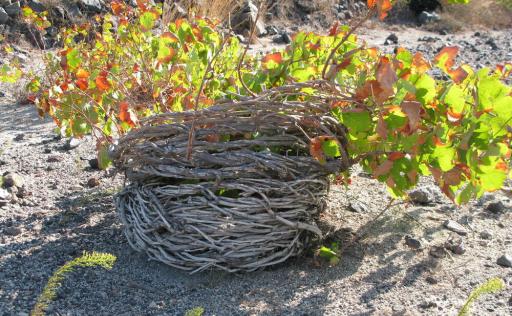
The bare, low-vegetation slopes and the air that easily carries pumice, subjecting plants to continuous sandblasting, forced the Santorinians to invent the cultivation of vines in basket-like forms. (image The Basket-like Form in Santorini's 'Vines')
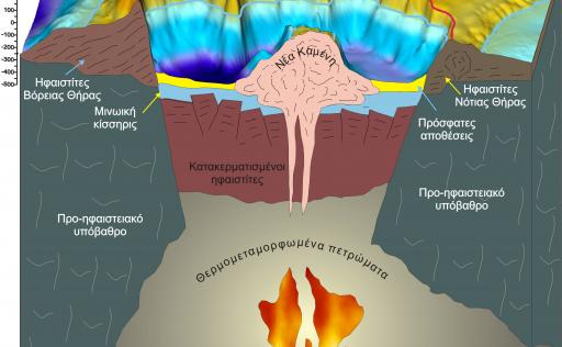
After the last major eruption, volcanic activity continued with mild explosive and effusive action in the center of the caldera, building an underwater mountain. The summit of this mountain first emerged with the eruption of 197 BC. Since then, eight more mild eruptions have built the islands of Palea and Nea Kameni.
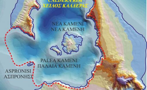
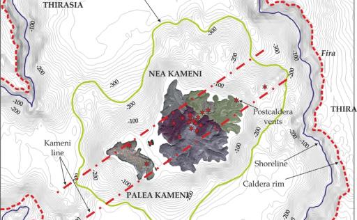
The last eruption occurred in 1950, creating the youngest landmass in the eastern Mediterranean, Nea Kameni. (image The island complex of Santorini, the boundaries of the Late Bronze Age caldera, and the post-caldera volcanic construction of Nea and Palea Kameni.)
In Santorini, the flora and fauna are poor since the Minoan eruption prevented any form of life from surviving in the area. Trees are scarce due to both the lack of water and the strong winds.
The morphology of the island's coasts is controlled by the presence of the caldera: within it, there are vertical, inaccessible rocky shores. On the external perimeter of the island, extensive smooth sandy shores develop.
Although rainfall is minimal (less than 40 centimeters per year), the lower layers of the "Minoan" tuff on Thira host a groundwater horizon open to the sea. The island previously met its water needs with a series of wells. Continuous over-extraction led to seawater intrusion into the aquifer, resulting in the very poor quality of the water currently extracted. A significant amount of water is produced by desalination units using reverse osmosis of seawater. There are also several hot springs.
Human presence in Santorini seems to have been interrupted only for 2-3 centuries, between 1600-1300 BC, due to the "Minoan" eruption. Throughout the rest of the time, it operated as a major commercial and cultural center. Agricultural production was always significantly developed, despite the lack of water. The excellent Santorini wine was the primary agricultural product. However, the main source of wealth was always its commercial fleet. Santorinian merchants and shipowners played a crucial role in the trade of goods in the eastern Mediterranean from the Bronze Age until the previous century. At the beginning of the 20th century, some manufacturing enterprises (tomato processing and textiles) were established, which were profitable for a few decades.
The island's population has always numbered several thousand residents. The devastating earthquake of 1956 caused a massive migration, mainly to Athens. The island began to develop again after 1970, when intense tourist interest emerged alongside the start of archaeological excavations at Akrotiri. Today, the permanent population is approximately 25,000.
The economy of Santorini relies primarily on tourism, which has grown dramatically over the last 30 years. The finds from the Late Bronze Age settlement excavations at Akrotiri and the unique landscape of the caldera slopes have established it as a high-end tourist resort. Mining activity has fortunately been banned for the last 40 years. Agricultural production has been largely restricted to the famous Santorini wine.
The following briefly describes the most interesting 8 routes on the island, with a primary focus on the geology of the area. For optimal understanding of the geological site, it is useful to have with you the simplified geological map of the area and the related routes, which you can obtain from the corresponding folder on the website. Before starting each route, carefully read the relevant information and follow the instructions of the "Visitor Behavior Guide," also found on the same website.
The Volcanoes of Santorini
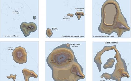
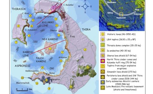
The rocks that existed before the volcanic activity in the area, what we call the pre-volcanic substrate, appear in southeastern Thira. This consists of limestone and schist, which build the mountain of Prophet Elias, the hill of Gavrilos, and the slopes of Athinios. These are rocks older than 100 million years, similar to those found on the neighboring islands of Ios and Anafi.(image The Stages of Creation of the Santorini Volcanic Field)
The first volcanic activity occurred in the broader area of Santorini about 2.5 million years ago, southwest of Santorini, creating a large volcanic structure. The group of islets of the Christians, Christiani, Askani, and Eschati or Mermigas are what remains after the fragmentation, partial submersion, and erosion of this volcano.
In the narrow area of the Santorini island complex, the first submarine volcanic activity occurred about 1 million years ago. The site of both the initial volcanic centers in the area and all subsequent volcanic centers in Santorini is controlled by a deep tectonic line, a major fault in the Earth's crust that starts from the Christians and extends to Amorgos. This is the main deep conduit that allows magma to rise to the surface.
This fault remains active to this day and was responsible for the largest shallow earthquake of the century in the Aegean, the 1956 earthquake that destroyed much of Santorini's settlements. Near the surface, the fault branches into two main volcanic-tectonic active lines, the Kolumbo Line and the Kameni Line. Along these lines, the centers of all volcanic activities have been located for at least the last 200,000 years.(image
The older volcanic centers of Santorini are found in the southwestern Thira, in the Akrotiri area. The first volcanic products were deposited in a sea with a depth of 200-300 meters. With the accumulation of volcanic rocks and the thermal uplift of the area, the volcanic centers emerged on land by the end of the early volcanic activity in Santorini, forming the current hills of Akrotiri,from the Lighthouse to Archangelos. The most reliable ages, as determined by radiometric dating of the first land lavas using the potassium-argon method, are between 645,000 and 586,000 years ago.
Subsequently, volcanic activity shifted northwards to the area of present-day northern Thira. There, a large shield volcano was built between 530,000 and 430,000 years ago, the Peristeri volcano (the main exposures are found today around the Peristeria bay). Its height did not exceed 400 meters, and the highest point where its lavas appear today is the Small Prophet. Concurrently with the activity of this large volcano, smaller volcanic centers were active to the south of it, around the then island of Akrotiri. Balos, Kokkinopetra, and Mavrorachidi (Red Beach) are three of these small centers, with ages between 520,000 and 345,000 years ago.
This is the period when the major eruptions in Santorini begin. About every 30,000 years since then, a huge explosive event occurs that throws billions of tons of volcanic ash into the air. Only a small part of this material is deposited on Santorini, creating the successive layers of ash that cover the entire area and build much of it. The main volume of ash ends up in the deep sea, while the finer particles are thrown tens of kilometers high and travel across the planet. Layers of fine ash from these eruptions have been found in sediments in the Mediterranean.
The most destructive aspect of these eruptions is the collapse of the pre-existing volcano and the formation of a caldera. As tens of cubic kilometers of magma are blasted into the air, the magma chamber is emptied, and the rocks above it collapse into depths of several kilometers, creating a caldera, a massive explosive crater that is immediately inundated by the sea. Inside this cavity, magma continues to rise—albeit more gently—and gradually fills it, beginning to build a new volcanic edifice.
This cycle of destruction and rebuilding of the volcano has occurred 12 times in Santorini over the last 360,000 years. Thus, while the thick layers of ash attest to the major eruptions, the volumes of solid lavas interbedded within them are witnesses to the construction of the volcanic centers that were then collapsed by these eruptions.
The Late Bronze Age Eruption
The last of the major eruptions in Santorini occurred in 1614 B.C. It was preceded by a severe seismic crisis that manifested a relatively short time, just a few dozen days, before the eruption began. Large-scale frequent seismic tremors destroyed the buildings and made life on the island very difficult.
The destructive volcanic activity began with two small explosive events. The first blasted a small amount of white pumice into the air. The second expelled fine yellow dust, along with large amounts of water vapor. This yellow mud trapped olive leaves and a large percentage of pollen grains from olive and coniferous trees. This indicates that spring was the season during which the eruption occurred, a fact supported by the conclusions of archaeologists working on the excavation at Akrotiri.
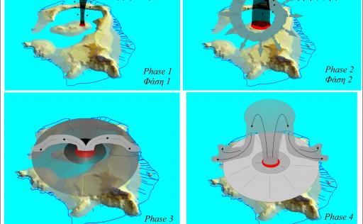
Subsequently, and without any significant interruption, volcanic activity peaked in a massive eruption, one of the largest known to humanity in the last 10,000 years. Four phases are recorded in the desite mechanisms of the eruption products.(image The phases of the Late Bronze Age eruption.)
During the first phase, a large explosive ash column is created, from which layers of coarse pumice fall at the base of the Minoan ash (fallout deposits). The height of the column reaches 30 to 40 kilometers, and the stratospheric winds, which in the area have an east-southeast direction, carry the main ash plume in this direction. The first phase lasts approximately 4-6 hours.
Erosion and opening of the eruption vent, which was located on an islet in the center of the caldera similar to the present-day Kameni islands, between the current Nea Kameni and Skaros, allows seawater to enter the crater and come into contact with the molten magma. The immense kinetic energy released by the evaporation of the water pulverizes large amounts of magma and ejects them at high speeds (80-200 meters per second), covering the entire area with fine white ash. This second phase further enlarges the eruption crater, allowing even more seawater to enter.
Thus, we move to the third phase, where large quantities of ash are ejected in the form of hot pyroclastic flows and build a large tuff ring, until the crater is isolated from the sea. Meanwhile, the crater has expanded greatly, and due to the emptying of the magma chamber from the expelled magma, the roof of the volcanic edifice begins to collapse.
Then, the fourth phase begins, where glowing clouds of shattered magma are ejected as fiery jets from various fissures of the crater-caldera and spill onto the slopes of the cone created by the third phase. In total, within a few days (4-6), over 100 billion tons of molten rock are blasted into the air. The pumice and volcanic ash produced cover the remaining island with a white blanket several meters thick and create all its flat surfaces on the northern and eastern coasts of Thira and the western coasts of Therasia.
The fine volcanic ash (or tephra) travels in the air to the east, spreading across the eastern Mediterranean and Asia Minor, depositing a layer of ash 30 centimeters thick on Rhodes - Kos and 15 centimeters in lakes of Asia Minor. The very fine ash and sulfuric acid droplets enter the stratosphere (at heights greater than 15 km) and cover the entire planet with their veil.
The collapse of the volcano into the massive underground cave created by the ejection of molten rock, which forms the present-day caldera of Santorini, as well as the previous entry of numerous pyroclastic flow currents into the sea, cause a series of tidal waves (tsunamis) that sweep across the coasts of the Aegean and the eastern Mediterranean shores.
Historical volcanic activity
From 1614 B.C. to 197 A.D., numerous small eruptions and extrusions occurred, building a large underwater volcanic mountain, the peaks of which are the Kameni islands (image The underwater and terrestrial volcanic structure of the Kameni islands)
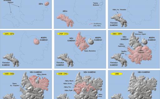
The first terrestrial activity is recorded in 197 A.D. by the notable Greek geographer Strabo, creating the islet of Iera, which was later eroded by the waves and recorded as the Bankos reef. Subsequently, 8 more eruptions have been recorded (46-47 A.D., 726, 1570-1573, 1707-1711, 1866-1870, 1925-1928, 1939-1941, 1950), which built the Kameni islands, the newest landmass in the eastern Mediterranean. (image The phases of the creation of the Kameni islands)
Two eruptions, in 46-47 A.D. the first and in 726 the second, created the then Thia, now known as Palaia Kameni.
The eruption of 726 was particularly strong, severely disrupting the economic and social life of the Aegean and was interpreted as a sign of the wrath of God in the conflict between iconoclasts and iconophiles, which at that time plagued the Byzantine Empire.
The next eruption, in 1570-1573, created Mikri Kameni, the first part of the present-day Nea Kameni.
The eruption of 1707-1711 created a second islet next to Mikri Kameni, which was named Nea Kameni.
The eruption of 1866-1870 produced large quantities of lava and significantly increased the New Kameni.
The eruption of 1925-1928 consolidated the islets of New and Small Kameni, approximately in the shape that New Kameni has today. There was considerable and spectacular explosive activity, which, however, did not create serious problems for the Thera inhabitants.
The eruption of 1939-1941 created the present peaks of New Kameni, while the last eruption, that of 1950, added only a small hill near its peak.
After the 1950 eruption, the volcano has been in a state of calm, with magma stored in shallow magma chambers beneath the Kameni islands.(image Schematic depiction of the current state of the Santorini volcano.)

Geotrail 1
Geotrails
Distance:
1.44 km
Altitude:
9-111 m
Duration:
40 minutes

Geotrail 2
Geotrails
Distance:
9.14
Altitude:
0-100 m
Duration:
216 minutes

Geotrail 3
Geotrails
Distance:
21.64
Altitude:
1-543 m
Duration:
505 minutes
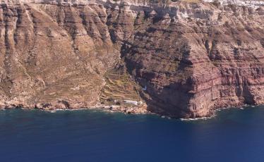

Geotrail 4
Geotrails
Distance:
5.53 km
Altitude:
11-256 m
Duration:
144 minutes


Geotrail 5
Geotrails
Distance:
19.21 km
Altitude:
5-336 m
Duration:
441 minutes
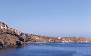

Geotrail 6
Geotrails
Distance:
12.52 km
Altitude:
0-255 m
Duration:
311 minutes


Geotrail 7
Geotrails
Distance:
81.63 km
Altitude:
-6-69 m
Duration:
1649 minutes


